Just in time for the anniversary of the Battle of the Brandywine, Chester County Archives and Records Services has released a new interactive tool that helps you discover who lived on your property in September 1777.
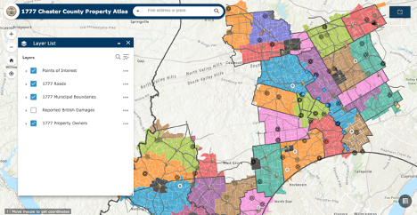
The 1777 Chester County Property Atlas is an interactive map that allows researchers to easily see who owned properties in 1777, and if those owners or occupants reported any losses caused by British troops during the Philadelphia Campaign of the Revolutionary War.
The culmination of years of research by Chester County Archives staff, the project’s original intent was to assist with interpretation and preservation of events surrounding the Battle of Brandywine.
After Archivist Cliff Parker developed a research methodology to map the public road network and locate residents who claimed damages, he saw the potential to expand the project into a historical atlas. As a result, most of the municipalities researched and mapped so far are in the southern portion of Chester County, where the military events unfolded. The project is ongoing, and additional township maps will be added as research is completed.
“It has been gratifying to see the project evolve into a major research tool for Chester County history,” said Chester County Archives Director Laurie A. Rofini. “What the Archives staff has produced is truly remarkable. Anyone who has attempted property research will recognize the enormous effort that had to go into this in order to create something so detailed, yet so accessible. I recommend looking at the instructional video that Assistant Archivist John E. Smith III created to really get a sense of the information behind the maps.”
Rofini says the project has increased understanding not only of events in September 1777, but also of the colonial history of Chester County. The research has contributed to planning reports that provide recommendations for historic preservation and open space preservation, as well as heritage interpretation and tourism for each municipality in the 35,000-acre battlefield. It has also led to the creation of a number of blog posts, story maps, and videos.
Chester County Archives and Records Services invites researchers to share their land ownership and ancestral stories on its Facebook page.
You Might Also Like
Chester County Launches Fascinating Digital Timeline of Local History
Sports Agent from Coatesville Brokers Richest Player Contract in History of American Sports
Marshallton Resident, WCU Grad Named President of Chester County History Center


")


")


")


")